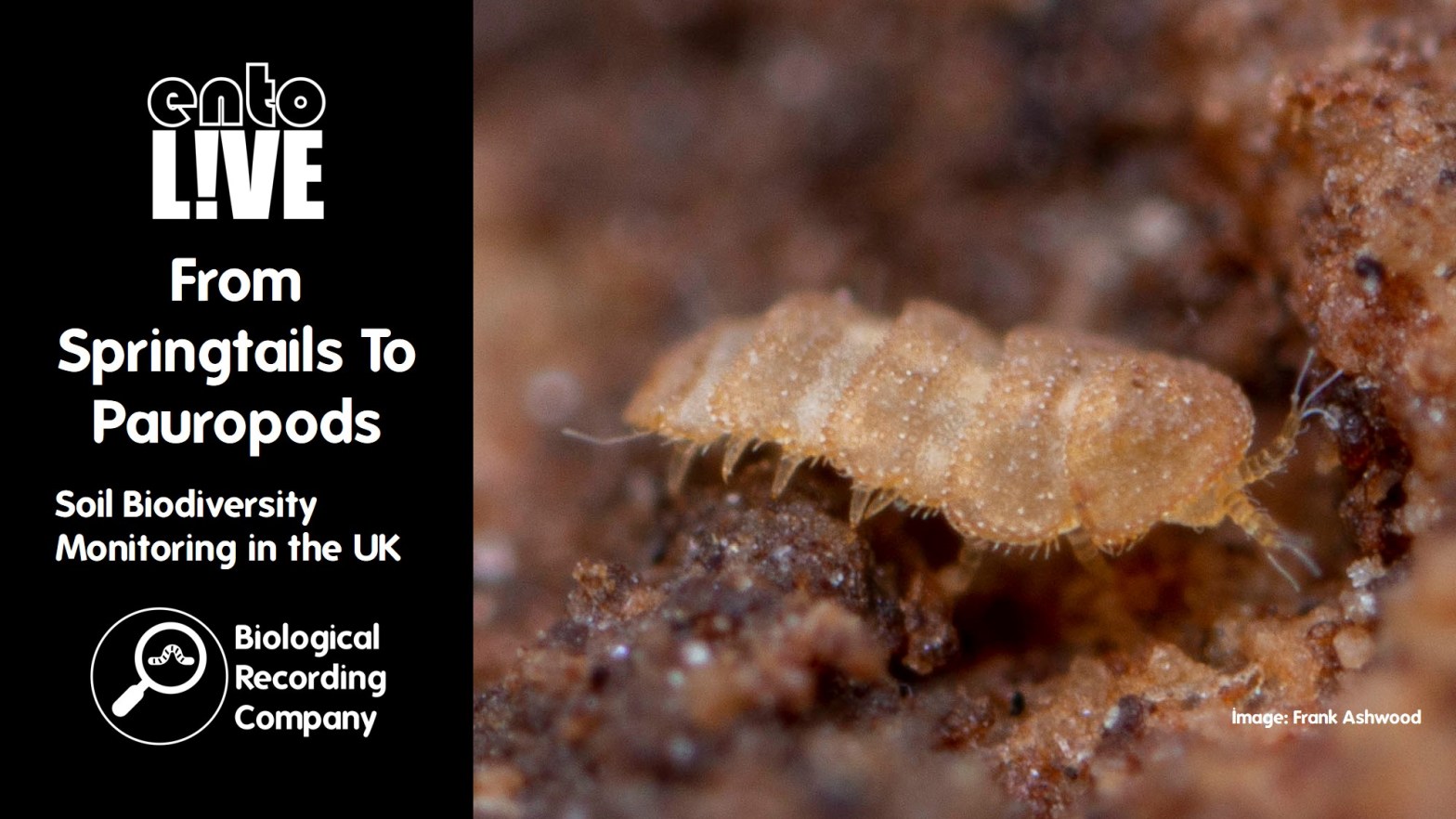
The State of the UK’s Butterflies: Are Conservation Efforts To Save Our Butterflies Working?

The UK’s butterflies are in trouble with half of them listed as threatened or near threatened and 80% having decreased in abundance, distribution or both since the 1970s. This talk will present the latest assessment of the UK’s butterflies, drawing on decades of data from citizen science recording and monitoring. Despite the gloomy overall picture painted by the long-term trends, numerous examples show that, given sufficient resources, conservation action can turn around the fortunes of threatened butterflies.

Q&A with Dr Richard Fox

Dr Richard Fox is Head of Science at Butterfly Conservation. He has been developing and running citizen science recording schemes for UK butterflies and moths, and analysing the results, for over 25 years.

  • Does The State of the UK’s Butterflies report use all survey data, including the Big Butterfly Count?
    In theory, it all contributes. The population trends come from the UK Butterfly Monitoring Scheme and the Wider Countryside Butterfly Survey as these use transects that can be compared between years. The data from various other recording schemes, including the Garden Butterfly Survey and the Big Butterfly Count, are passed on to County Recorders that check the records and verified records enter the Butterflies For the New Millenium database (the national recording schemed for butterflies). We’ve analysed the Big Butterfly Count data and shown that the changes from year to year for the unverified data closely match changes from the UK Butterfly Monitoring Scheme.
  • Is data available for the Republic of Ireland and are the trends the same?
    Butterfly Conservation covers Northern Ireland but not the Republic of Ireland. The data holding organisation for Ireland is the National Biodiversity Data Centre and they organise a monitoring scheme that also involves transects. It hasn’t been running as long as the UK scheme. They also collate distribution records. An Ireland butterfly atlas is in progress, though I’m not sure when this is due.
  • Are a lot of the range expansions into Scotland due to climate change?
    Yes, I think it is mostly due to climate change. We’re a collection of relatively cool and damp islands off the coast of Europe and all of the butterfly species that occur in the UK are also found in other parts of Europe. Many of these species reach a climatically determined edge to their range in the UK and Ireland. Most of these species are southerly species and adapted to warmer conditions, and they are now able to survive further north. We also have some cold-adapted species, such as Northern Brown Argus, Mountain Ringlet and Scotch Argus, that we don’t get in the southern parts of Britain and these species may see their ranges retract further north and uphill.
  • Should conservation efforts focus on the rarest species of butterfly?
    The Red Listing process was created and is managed by the IUCN and is a global standard to measure the risk of extinction of a species, – not its rarity nor conservation priority. Just because something is listed as Endangered on a Red List does not necessarily mean that a species should be a conservation priority. Factors that need to be considered include how much we know about a species, do we know how to conserve the species effectively, how much will conservation interventions cost and how pragmatic is it to try to conserve a species. The Small Heath is a species on the Red List that is still very widespread in the UK so it is hard to imagine what we can practically do at a species level. Another species may not be declining at all, but have a very restricted population (i.e. be considered rare) with reasons to worry about its future. Undertaking local conservation interventions that are likely to have an impact on the restricted species may therefore be the conservation priority.
  • Are there any other captive breeding for butterflies designed to retain genetic diversity?
    As far as I’m aware, there aren’t any captive breeding schemes for UK butterflies that are going on for the sake of retaining genetic diversity itself. However, there are other captive breeding projects underway to reintroduce butterflies to areas where they have been lost. The Cumbrian Marsh Fritillary Project example that I gave in my presentation involved taking caterpillars from that last web and crossing them with individuals from Scottish populations before release. Reintroduction only works when there is the necessary habitat management in place – it’s not a good idea to introduce butterflies into an area if there is no suitable habitat.
  • Are there illegal non-conservation releases and does this impact the data?
    It can be a problem for the data, as it can make the data difficult to interpret – for example, a population could look healthy if a species is being repeatedly introduced in an area and this may result in a lack of conservation interventions where they are needed. It can also be illegal, for example releasing them onto a protected site such as a SSSI or releasing a non-native species.
  • What is the best thing that the general public can do to help butterflies?
    The best thing would be for people to let their grass grow long and allow wildflowers and “weeds” flourish. This can be a patch within the garden, and these can be rotated in different years. We need to consider both the adult and larval (caterpillar) stages of butterflies and regularly mowing grass removes important habitat for caterpillars. Plus it costs nothing to do! No Mow May is a great initiative to get people thinking, but it isn’t long enough to have a significant impact. We need No Mow Year!

Literature references

Further info


entoLIVE

entoLIVE webinars feature guest invertebrate researchers delving into their own invertebrate research. All events are free to attend and are suitable for adults of all abilities – a passion for invertebrates is all that’s required!

entoLIVE is only possible due to contributions from our partners.


More on invertebrates

The Downland and Dung Beetle Project: The Story of Onthophagus joannae

Dung beetles are vital to healthy soil systems where livestock are present. They perform a variety of ecosystem services, and are in turn, a food source for other invertebrates, reptiles, birds and mammals. Research has now shown that only a quarter of all UK dung beetle species remain in a state of ‘least concern’ with the rest considered regionally extinct or threatened. We have already lost species of dung beetles entirely due to extinction in the UK. A previously well-established dung beetle in this area, Onthophagus joannae, was noted to be now regionally rare to regionally extinct. One very small extremely vulnerable population was found to be remaining on the calcareous grassland bank near Berrycroft Hub, inhabiting a very small area of considerably less than half an acre. Hear about how one person’s accidental restoration of a large area of downland due to a personal obsession to conserve one particular species of dung beetle.

Q&A with Sally-Ann Spence

Sally-Ann Spence is a farmer & an entomologist who specialises in dung beetles & pastureland biodiversity. She founded the UK Dung Beetle Mapping Project accumulating species data. Her work with the project has seen her surveying field sites all over the UK including many outlying islands enabling her to study a multitude of grazing systems. This practical experience has been translated into collaborative projects working on sustainable land management plans within the farming community to promote dung beetles as important bio-indicators for soil, pasture & livestock health. As a founding member of Dung Beetles for Farmers, she remains a passionate advocate of British farming & biodiversity.

Where in the UK is your project?

It’s literally on the Berkshire/Oxfordshire county border, in the North Wessex Downs ANOB. The main grassland area is within Oxfordshire & neighbours the Ashdown House National Trust estate near Swindon.

Are dung beetle species specific to the dung of a given animal (for example sheep, rabbits, cows etc.)?

You get both generalists and specialists. Generalists tend to be less threatened as they can make use of a wide range of dung providers. For example, I’ve found Acrossus rufipes on all sorts of dung including Rhinoceros (Cotswold Wildlife Park) and Red Deer on the tide line in shingle on a beach on the Isle of Arran. Specialist invertebrates tend to be more at risk due to their specific needs. You have specialist dung beetles when it comes to dung type. For example the Minotaur Beetle (Typhaeus typhoeus) will only choose dung that is in a pelleted form, such as rabbit, deer and sheep dung – but it wouldn’t make use of the sloppy dung sometimes generated by sheep, only when it is in the pelleted form. Bigger dung beetles are often only associated with bigger animals (such as horses and cattle) just because of the sheer amount of dung that they require.

Do you see Environmental Land Management Schemes (ELMS) helping dung beetle populations?

These schemes encourage farmers to undertake more conservation-based farming, for example including wildflower mixes (as well as encouraging Red Data List species). It is the presence of livestock that will help dung beetles. There is a move away from livestock that is occurring due to a number of factors, including a meat free diet. Regenerative farming is a practice that can involve introducing livestock and grazing onto arable farmland, by using a cover crop over winter instead of bare soil. Cover crops (such as stubble turnips), which is then grazed by livestock. Undisturbed soil is also important for dung beetles. Livestock being kept indoors (such as breeds that struggle with our winters & for logistical reasons/ground conditions) can also be problematic for dung beetles, as we have species that are active all year round. Schemes can be quite rigid and every farm/farmer is different. What is good in one area for one species, may not be so in others.

Are you using any worming treatments (such as ivermectin) and what is the impact on dung beetles?

The impact of ivermectins is massive and goes beyond dung beetles. These chemicals are persistent and do not break down quickly after use within the animal – being transferred into the soil through the dung. Any treatment for parasites is an insecticide. It is possible some species appear to avoid dung that contains the active insecticides within these treatments, whereas others will still feed on the dung. Those beetles that consume contaminated dung will die. Other species will come in a bit later on when the dung being produced is less toxic and experience sub lethal effects -impacts on their navigation, fertility, larval and pupae development. As dung beetles are the catalyst for creating the communities within dung, this has a knock-on effect on the whole dung invertebrate community. Dung that isn’t broken down by dung beetles and the associated invertebrate communities will persist in the field for much longer as decomposition is then reliant on fungi and bacteria. It is a particularly difficult and complex subject as farmers need to control these parasites in order to ensure their animals welfare and that their business is financially viable. We need an alternative treatment that does not persist in the dung and we need to think about practices that enable us to use less of these insecticides. This is something I am passionate about and address in my workshops within the farming community. I have put a lot of work into my own livestock on many levels over the years to try to reduce usage. Despite making huge inroads I do still have to treat some individuals and have a management plan in place for this. Those animals that require treatments are removed from the calcareous grassland area and treated in a quarantine paddock. I am also working with many different projects across the U.K. trying to find alternative solutions and keen people appreciate these chemicals are used in the pet industry as well.

Further info


entoLIVE

entoLIVE webinars feature guest invertebrate researchers delving into their own invertebrate research. All events are free to attend and are suitable for adults of all abilities – a passion for invertebrates is all that’s required!

entoLIVE is only possible due to contributions from our partners and supporters.


More on invertebrates

Can Satellite Imagery Data Be Used For Biodiversity Net Gain?

Achieving Biodiversity Net Gain with all developments will be legislated in November this year in England. Understanding the presence and health of ecosystems on both proposed development sites and sites being used for biodiversity offsets is a pivotal component of this for ecologists to produce habitat condition assessments.

This blog discusses the potential role of satellite imagery in the use of habitat condition assessment and monitoring, and if there is a role for it alongside traditional on-the-ground surveys. A live virtual symposium was held on 15 November 2023, with presentations from Dr Dan Carpenter (an ecologist) and Richard Flemmings (a data scientist), followed by a transcript of a panel discussion that was hosted by Sally Hayns (CEO of the Chartered Institute for Ecology & Environmental Management).


The Role of Satellite Data in Biodiversity Net Gain

Dr Dan Carpenter (Digital Ecology)

With an increasing range of sensors, ever-improving resolution, and frequent data updates, satellite represents an enormous resource for observing planet earth. Myriad environmental applications have already been found for satellite data, but where might it be useful in biodiversity net gain? In this talk, Dan Carpenter will share his thoughts on the potential applications, as well as the limitations, of satellite data for BNG.

Dr Dan Carpenter is a Digital Ecologist working at the interface of ecology and digital technology. He is interested in how digital tech can be harnessed to help deliver better biodiversity outcomes.

  1. Walrus from space: https://www.wwf.org.uk/learn/walrus-from-space
    Elephants from space: https://www.bath.ac.uk/announcements/counting-elephants-from-space/
  2. Rainforest deforestation tracking: https://earthobservatory.nasa.gov/images/145988/tracking-amazon-deforestation-from-above
  3. Wildfire monitoring: https://earthobservatory.nasa.gov/images/151407/raging-fires-in-nova-scotia
  4. Digital Ecology website: https://digital-ecology.co.uk/
  5. Follow Digital Ecology on LinkedIn: https://www.linkedin.com/company/digital-ecology/

Satellites for Environmental Monitoring – Advantages and Limitations

Richard Flemmings (Map Impact)

Satellite data has long been used to measure environmental variables. The view from above has the advantage of covering large areas of the landscape, whilst collecting consistent and repeatable data that is objective. Combined with novel data analytics approaches, satellites can provide indicators of vegetation quality, vigour and biodiversity at scale. However, there are many things that a satellite cannot achieve. This candid presentation will draw on case study examples to demonstrate what satellites can and can’t achieve.

Richard Flemmings has specialised in applying geospatial and satellite earth observation data to environmental challenges throughout his career. He is interested in taking a highly collaborative approach to ensure that these data feeds can benefit as much of society as possible.

  1. More info on the BiodiversityView tool: https://www.mapimpact.io/product/biodiversityview/
  2. Check out the MapImpact website: https://www.mapimpact.io/
  3. Get in touch with Map Impact to discuss their products and services: info@mapimpact.io
  4. Follow Map Impact on LinkedIn: https://www.linkedin.com/company/map-impact/

Satellite Imagery for BNG Panel Discussion

Hosted by Sally Hayns (Chartered Institute of Ecology and Environmental Management)

  1. What’s a ‘spatial framework’?
    Dan. A spatial framework is where there is an agreed set of boundaries for representing data. For example, OS MasterMap, where OS have mapped all of the polygons on the ground that we can then apply information to it, such as noting the habitat of a polygon.
    Richard: UKHab is trying to bring together a framework for habitats that is the defacto framework that everyone uses. Map Impact uses a hexagon framework that works not just for the UK, but globally.
  1. How is woodland condition assessed?
    Dan: Woodland condition is assessed on the ground using the condition assessment provided alongside the metric provided by Defra. This uses a set of criteria, including structural diversity, deadwood etc. These data are shared with Map Impact, who then look at if they can detect the same woodland condition based on satellite imagery.
    Richard: With the satellite data, we take each piece of woodland and look at the satellite spectral signatures to understand how it is performing. This is compared with all of the surrounding woodlands within a 10 km radius. This tells us where it sits in terms of performance.
  1. Does Map Impact use its own dedicated land classification system to contribute to its map or is it solely based on a collation of other open-source land cover maps and parameters?
    Richard: Currently this is solely based on a collation of other open-source information.
  1. What are the sources of open data already available for habitat mapping?Dan: Natural England Living England data – this is good for habitat data currently on version 4 and is constantly being updated. There is also the CORINE Land Cover, Open Street Map Land Cover data and the CEH Land Cover Maps.
    Richard: The open data that we are using includes all of the data mentioned by Dan, but also incorporates part of the open Ordnance Survey datasets and several other habitat layers published by Defra and Natural England (such as their priority habitats data). We’ve initially focused on England while building this dataset, but we’re also in the process of expanding this to cover Northern Ireland, Scotland and Wales and hope to have these UK-wide datasets ready by early 2024.
  1. Is there any provision for mapping smaller habitat segments that might be part of corridors or stepping stones?
    Richard: There is some really interesting work going on around habitat mapping. That’s not something that Map Impact are currently directly addressing – we are using open-source habitat data to feed our tool. There is potential for small habitat segments to be mapped down to a high level of detail. However, there is a trade-off as it can be quite costly to obtain imagery at this fine level of detail. It may be more cost-effective to actually send out a surveyor, so it is important to consider financial viability.
    Dan: There are a number of other methods for gathering these data that may be much more cost-effective, such as ground surveys, LiDAR and UAV. The power comes from combining these sources of data and picking the right tool for the right job.
  1. What size of land holding can your tool provide a screening assessment and habitat quality overview for?
    Richard: The minimum area size that we are currently providing is 10HA within the BiodiversityCheck report.
  2. Is there a repository for this UK Hab / condition assessment data to improve accuracy in these models going forward?
    Sally: Many ecologists are carrying out UK Hab condition assessments on a daily basis and it would be great to have these collated in local repositories, possibly hosted by Local Environmental Record Centres.
    Richard: This doesn’t yet exist, however, as Sally said, it would be great to have ecology surveys and condition assessments collated in local repositories, possibly hosted by Local Environmental Record Centres.
  1. Have you explored higher-resolution RGB imagery?
    Richard: We are using Sentinel-2 data. We have looked at higher-resolution data but the coverage and cost are not suitable to provide a country-wide and consistent dataset. The model uses existing open source datasets to identify the habitat type, and depending on the habitat type, a number of satellite-derived indices are applied to observe the condition using a range of scores that then align with a “Good, Moderate, Poor” condition for that habitat. These are assigned a confidence score based upon comparisons between the satellite observations for the habitat, compared with ecologist observations on the ground using the Defra Biodiversity Metric Calculator.
  1. How much ground truthing of these outputs has been undertaken and what level of confidence do you have by habitat type?
    Richard: The approach that we’ve taken assigns a confidence score for each report, with a banded level of confidence ranging from high to low. This is calculated based on comparisons between the satellite data and on-the-ground surveys by ecologists to understand how accurate the satellite data is. We’ve collected hundreds of points this year, but we are aware that this isn’t enough and we’ll continue to keep adding ground-truthed data as time goes by. The more we add, the more the confidence levels will improve. There are limitations to when we can do the ground-truthing For example, we need to assess grasslands in summer (and ensure we are comparing these to satellite imagery taken during summer).
    Dan: The ground-truthing is essential to give users the confidence that the numbers coming from the satellite data reflect reality. I’ve been working with Map Impact to go out and do various habitat condition assessments across England. We’ve also worked with others who can provide data that has been collected in the same way. We have a programme for next year to gather more data and try to capture some of the subtleties, such as capturing the different types of grasslands and sub-habitats.
  2. Is this screening assessment a valid BNG baseline survey using metric 4.0 and could replace the need for an ecologist’s survey on the ground?
    Richard: The satellite approach does not replace the need for an ecologist to provide an in-situ ground survey that is compliant with the requirements of the Defra Metric Calculator.
  1. Do you think we will be using satellites for monitoring offsetting sites into the future over the next 30 years, to ensure they are being appropriately managed?
    Richard: Satellites are a very useful tool to consistently and repeatably observe sites over long periods of time to ensure appropriate management. However, it is important to use a consistent data source and a consistent approach in terms of level of detail and output. This will ensure that sites are monitored in a consistent way and that comparisons can be drawn over a long period of time. Sometimes, improving the level of detail will make this a difficult task to achieve.
    Dan: I think satellite data will be part of the tool kit of monitoring, but really we need to be thinking about more integrated approaches to monitoring, that make the best use of data, technology and surveys to really determine the success or otherwise of BNG.
  2. Corporate reporting frameworks like TNFD recommend using the Biodiversity Intactness Index and the Ecosystem Integrity Index, do you think there is scope to use these to track and monitor sites under BNG or other compliance schemes?
    Richard: Yes, there is scope to align monitoring requirements to potentially fulfil the needs of both BNG and TNFD. Whilst different frameworks are being developed that align with different reporting requirements, it’s important that they remain flexible enough to allow cross-compatibility. Satellites are a potential common data source that offers the wide area coverage and objectivity needed to link these frameworks together.
    Dan: The Biodiversity Intactness Index is a species-based index, so satellite data are not appropriate here. However, they may be used in part to help with determining the Ecosystem Integrity Index which looks at measures of structure, function and composition.
  3. What role do you think AI could play in this technology?
    Richard: There is huge potential for AI considering the amount of data that is being captured. The number of satellites gathering data is constantly increasing, resulting in an enormous amount of data. There are limits to how much data humans can reasonably trawl through so AI provides great potential to extract the information that is useful from these huge data sources.
    Dan: It’s important to remember that the term AI is applied to a range of things, not all of which will be applicable to analysing satellite data. As Richard has explained, machine learning and deep learning (i.e. using computers to look at patterns) are where I see the real value of AI in complementing the skills of data scientists and ecologists to analyse the data.

Event Partners

This webinar will be delivered by the Biological Recording Company in partnership with Map Impact and Digital Ecology.


More for environmental professionals

Slipping Under the Radar: Recording Slugs in British Gardens

Slugs are widely known as a problem for gardener’s, but surprisingly little recording has been done in UK gardens for them. In this talk we hear about the citizen science research Imogen has been running; from the species-specific Cellar Slug survey, to “Slugs Count” the first in-depth study of the British garden slug fauna since the 1940s. We’ll hear how over 22,000 new slug records made by the public have helped inform our understanding of the slug fauna in Britain and evidence the large scale changes we are seeing over recent decades.

Imogen Cavadino looked at the slug species diversity and ecology in UK gardens as part of her PhD with Newcastle University and the Royal Horticultural Society. She is ordinary committee member for the Conchological Society of Britain and Ireland, council member for National Forum for Biological Recording and acts as a verifier for terrestrial mollusc records on iRecord. She is a keen advocate for this often unloved and overlooked fascinating group of terrestrial invertebrates.

Q&A with Dr Imogen Cavadino

  • If I have photos of possible cellar slugs, where can I send them for identification?
    It’s best to submit your record with photos to iRecord and Chris or I will try to give some helpful feedback. We welcome records where the recorder has made their best guess – just indicate with the certainty field that you are ‘uncertain’. If you’re really not sure which species it is, you can always submit it to genus level only (i.e. a record of Limacus) and we’ll try our best to get it to species from the photo. You can also submit to the Facebook group to get a second opinion, or just Tweet it to me and I’ll reply there.
  • There seem to be gaps in some parts of the UK, such as southwest Scotland. Is this due to a lack of species present in these areas or did you not get full coverage of the UK?
    We tried to get as much coverage of the UK as possible, but there were gaps. We had coverage from the applications, but some of these weren’t able to take part. We started recruitment just as Covid hit the UK so it was quite a challenging time for people. Although the project is finished, records for these areas can still be submitted through iRecord to help the recording scheme fill some of these gaps. I’m always happy to undertake freelance courses in these areas for any projects or organisations that have funding for delivering training.
  • Is the Budapest Slug pests of anything and should we consider thinking about how to conserve them?
    They are considered a pest of root vegetables and are quite common in semi-natural habitats. As a non-native species, we usually wouldn’t prioritise them for conservation. For molluscs, we only consider species that have been here since the last ice age. What constitutes a native species is highly debated.
  • Are the hybrid slugs fertile or are they unable to reproduce sexually?
    As far as we are aware, the hybrid slugs are all fertile and able to breed. Hybridisation is highly complicated and appears to be more common in some genera than others.
  • Was the Barnes and Weil research driven by the ‘Dig For Victory’ campaign or just for an interest in slugs?
    Barnes was definitely into his slugs! Barnes did another study that you definitely wouldn’t get away with today. He introduced a highly pestiferous pest species (Deroceras reticulatum) into the garden of a property he owned to see how the population fared – and it grew exponentially!
  • What is it that attracts slugs into houses?
    Some cases will be purely accidental, but some cases may be due to certain things that they are attracted to. They like things that are damp and can be attracted by foodstuffs, like animal feed or damp cereals – so you do get them attracted to pet bowls. they used to enter my parent’s kitchen regularly but all of a sudden stopped – I think partly because my parents installed underfloor heating!
  • Do Leopard Slugs eat other slugs?
    There is evidence that Leopard Slugs (Limax maximus) will attack other slug species. It’s likely that this is territorial rather than predatory. They will also feed on dead slugs. We don’t have strong evidence to show that they attack and eat other slugs as a common behaviour as most of the cases where this has been observed are under unnatural laboratory conditions.

Literature references

Further info


entoLIVE

entoLIVE webinars feature guest invertebrate researchers delving into their own invertebrate research. All events are free to attend and are suitable for adults of all abilities – a passion for invertebrates is all that’s required!

entoLIVE is only possible due to contributions from our partners and supporters.


More on molluscs

Team PollinATE: Feeding People and Pollinators

Over one-third of all the food we eat relies on insects for pollination. While there is increasing interest in urban food growing as a more sustainable option for meeting the nutritional needs of city dwellers, we currently know very little about pollinator populations in urban areas. Beth reports the results of a recent study that harnessed the power of citizen science and engaged urban growers themselves in collecting data on the bees, beetles, butterflies and flies that pollinate fruit and vegetable crops in urban areas.

Q&A with Dr Beth Nicholls

Dr Beth Nicholls is a research fellow at the University of Sussex with over ten years of experience studying the ecology and behaviour of bees. A major motivation for her research is to contribute solutions for the dual challenges of halting insect declines and producing food more sustainably.

  • Were there any differences between surveys conducted by you personally and the surveys conducted by citizen scientists?
    Yes – I separated out bumblebees, honeybees and solitary bees, whereas the citizen scientists only distinguished bumblebees from other bees. the paper that I’m working on at the moment is comparing my data with the citizen scientist data and look forward to publishing the results of this comparison in full soon!
  • Did any of the allotment sites have beekeepers on site and, if so, did you see any difference in visiting insects?
    Honeybees on allotments can be quite a controversial topic. We did note down where these were present, but honeybees can fly over such a long distances anyway and there was no way for us to know if there were nearby hives in gardens etc. that the bees may be coming from. As an urban area and with urban beekeeping on the rise (see the London Bee Situation entoLIVE for more on this), Brighton likely has a high density of honeybee hives. Honeybees were the most observed insects across all of the plots regardless of onsite hives.
  • How can we distinguish if an insect is a pollinator or pest?
    Insects may act as both, just at different parts of their life cycle. Larval stages may feed on parts of the plant and then the adults may provide pollination services. Some larvae may also act as predators of herbivorous insects. there’s a lot we don’t know about individual species, particularly at larval stage, and it can be really difficult to tell species apart. For example, people often mistake hoverfly larvae (which will grow into pollinating adults) for mosquito larvae. Really we want to strive for balanced ecosystems with healthy populations of predators of species that can become pests.
  • Following this study, will the research continue and be expanded into other areas?
    A nutritionist PhD student is continuing the work in Brighton, looking at community growing and what impact this has on diet choices, food availability, health and wellbeing. A second PhD student is taking the research beyond Brighton to other urban areas, focusing on perennial crops (such as hedgerows and trees) and looking at the impact on other benefits such as the heat island effect and flooding.

Literature references

Further info


entoLIVE

entoLIVE webinars feature guest invertebrate researchers delving into their own invertebrate research. All events are free to attend and are suitable for adults of all abilities – a passion for invertebrates is all that’s required!

entoLIVE is only possible due to contributions from our partners.


More on citizen science

The Rothamsted Insect Survey NBRI: From Microscopes to Machine Learning

The story of the Rothamsted Insect Survey (RIS) starts back in 1964 at a time when the Beetles released Can’t Buy Me Love’ and that finishes sometime in the future when entomology might look quite different. The RIS monitors many groups of insects using its 12.2 m suction-trap and light-trap data networks. James discusses insect declines and the work of the RIS. James is joined by Dr Yoann Bourhis who talks about the DRUID (Drivers and Repercussions of UK Insect Declines) NERC-funded project and demonstrates a citizen science app that uses machine learning to predict where species might be, extending our knowledge about current species distributions.

Q&A with Dr James Bell

Dr James R. Bell is a Principal Scientist and Head of the RIS, a BBSRC National Bioscience Research Infrastructure. James is a quantitative ecologist with expertise in entomology having published widely on beetles, spiders, aphids, moths and many other things besides. James is senior author on Practical Field Ecology: A Project Guide which offers a comprehensive, accessible introduction to experimental design, field monitoring skills for plants and animals, data analysis, interpretation and reporting. The book is now in its second edition.

  • How are aphids able to develop resistance to insecticides when they reproduce asexually through parthenogenesis?
    It’s a complex story. They may have metabolic resistance, meaning they have a way of dealing with insecticides inside their guts so that there is no overbearing negative effect on their performance. They may have target-site resistance. This is quite complicated to explain. These two mechanisms mean that aphids can adapt very quickly. For example, the Peach Potato Aphid (Myzus persicae) is the species that transmits the viruses in sugar beet and it is remarkable in that there is almost no insecticide that it can’t evolve resistance to. This complicated story can only be unravelled by studying the genetics of aphids. Regarding the parthenogenetic component, this is part of the story but aphid reproduction is often more complex. For example, peach is the primary host of the Peach Potato Aphid where it overwinters and reproduces sexually, enabling the population to acquire resistance. Any individuals that are susceptible to an insecticide would pass this on to any daughters (and subsequent generations) produced through parthenogenesis as the genome is not really changing (aside from small changes occurring due to mutations).
  • Where is the best place to look for research/observations that have been made about the symbiotic relationship between aphids and other insects?
    there is a book by A. F. G. Dixon title Aphid Ecology An optimization approach that provides an introduction to aphids. The issue with learning materials about aphids is that there isn’t much in the way of aphid citizen science so the literature tends to be aimed at an academic audience. I’m not aware of a resource where you could access this data, so all I can recommend is trawling through the data. Alternatively, you could grow broad beans in your garden and you’ll get the Black Bean Aphid (Aphis fabae) and the associated ants so you can observe them yourself!
  • What proportion of the sugar beet crop is for human rather than cattle consumption?
    Great question. Each field that is used for sugar beet crops is contracted by British Sugar by the field, so we know about every field that is used for this crop. At the moment 80,000 hectares of sugar beet are grown across East Anglia. The best sugar beet will achieve a sugar content of 16%. If the sugar content is too low, a farmer may decide to send it to fodder (or take a penalty on their contract). Therefore,  it is hard to answer this question as it is up to individual farmers what happens to the fodder crop and it will also depend on the season. We can only comment on the proportion that was rejected and not what the end use of that crop was.
  • How much do we know about aphids outside of agricultural research?
    I’m only aware of a single person in the world who is actively trying to conserve aphids. Everyone else that I know is trying to understand how we can control them and limit their population growth. Interestingly, they are different from other groups where the species diversity decreases towards the tropics. We don’t really understand why. There are still lots of avenues for interesting research when it comes to studying aphids outside of agricultural systems.

Dr Yoann Bourhis is an ecosystems modeller, with expertise in machine learning. Yoann’s main activity is as a post-doc on the DRUID project, funded by NERC. DRUID will take an unprecedented amount of citizen science data to underpin evidence-based policies to help nature. A key paper relating to Yoann’s presentation was published in Methods in Ecology and Evolution earlier this year and demonstrates how it is possible to use machine learning to understand the distribution of insects using their life history traits (e.g. wing length, host plants etc) and environmental drivers (temperature, rainfall etc) to predict new distributions of insects.  It is hoped that this new knowledge will guide recorders to sites where the species is predicted but no survey has yet confirmed the presence of that species. Yoann has developed an app and we invite you to contribute your experience and expertise.

Literature references

Further info


entoLIVE

entoLIVE webinars feature guest invertebrate researchers delving into their own invertebrate research. All events are free to attend and are suitable for adults of all abilities – a passion for invertebrates is all that’s required!

entoLIVE is only possible due to contributions from our partners.


More on invertebrates

Riverflies: The Canary of Our Rivers

Riverflies, along with other freshwater invertebrates, are at the heart of the freshwater ecosystem and are a vital link in the aquatic food chain. Their common characteristics of limited mobility, relatively long life cycle, presence throughout the year and specific tolerances to changes in environmental conditions make them good biotic indicators of water quality and useful indicators of change.

The Riverfly Partnership has developed the Riverfly Monitoring Initiative to enable citizen scientists to assess and monitor the health of rivers in their communities. Anglers, conservationists, and concerned community groups can act as guardians of the river by using the standardized monitoring technique developed by the Riverfly Partnership, in effect becoming an early warning system detecting disturbances in river water quality and raising the alarm, so that relevant statutory bodies can investigate further. Data collected by monitors is freely available to all and has been used to successfully prosecute polluters, showing the power of citizen science.

The Freshwater Biological Association provides an overview of the methodology, sharing the progress of the project and what’s in store for the future. Case studies are discussed that highlight the amazing work of the volunteer monitors and how you can get involved.

Q&A with Trine Bregstein

Trine Bregstein joined the Freshwater Biological Association in March 2022 as a citizen science coordinator. She has an interest in engaging people with conservation initiatives, helping them to foster a connection with nature and their local environment. The Riverfly Partnership is hosted by the Freshwater Biological Association.

  • Do cased caddisflies create a new case after every moult?
    I believe that cased-caddis flies add to their cases as they grow – repairing and upgrading the case as they go.
  • Is there any guidance available for obtaining permission to monitor a site from the landowner?
    We don’t have a guidance document for this – but it would be a really useful thing to have. With rivers, it can be tricky to figure out who the landowner is and not all landowners are keen to grant permission on their site. we’re always happy to give advice on how to sweet-talk landowners. You can find out more information about getting involved with the Riverfly Monitoring Initiative here.
  • How long did it take the River Kennet to recover from the pollution incident?
    It did take quite some time. The RMI detects the change in the macro-invertebrate community and this will have knock-on effects later on. In the River Kennet the Environment Agency monitored the situation and conducted electro-fishing (a sampling method to enable them to capture and assess the state of fish populations) at a later date. The Thompson et al. (2015) paper gives a lot more detail and is worth having a read for more information on this case study.
  • Can pollution fines be used to fund training and equipment in river monitoring?
    Last year the government stated that money from fines will be ring-fenced for work to improve water quality, such as initiatives to restore our water environments by creating wetlands, re-vegetating river banks and reconnecting meanders to the main channel of rivers. I don’t know specifically what it has been used to fund or how it is allocated. On our Get Involved page, there is guidance on fundraising for local groups that want to get set up and links to directories that can help you find funding.
  • If you find non-native animals, like Chinese Mitten Crab, when sampling should you return them to the water course?
    For non-native species, we would always advise checking out the Invasive Non-Native Species guidance online and ensuring you understand the legislation relevant to the UK country that you are surveying within. In England and Wales (at the time of writing on 18/09/23), if you accidentally catch a listed invasive alien animal during ringing or monitoring operations of other animals, you will not have committed an offence if you immediately release it (or you can also take it to a facility with a licence or permit). If you find a non-widely spread animal on your land or in the wild, you must report it to the non-native species secretariat. As the Chinese Mitten Crab is listed as a widely spread animal, you do not have to take any action but it is still useful to record your sighting through the Non-native Species iRecord Form.

Literature references

Further info


entoLIVE

entoLIVE webinars feature guest invertebrate researchers delving into their own invertebrate research. All events are free to attend and are suitable for adults of all abilities – a passion for invertebrates is all that’s required!

entoLIVE is only possible due to contributions from our partners and supporters.


More on freshwater biology

FSC BioLinks: Biological Recording & Training Consultation

The FSC BioLinks Project was a £1.6 million biological recording and ID training project run by the Field Studies Council with a large number of project partners and funded by the National Lottery Heritage Fund. This blog is the first in a series by Keiron Brown (Biological Recording Company founder and former FSC BioLinks Project Manager) sharing the successes, challenges, lessons learned and legacies of the project.

A 10-month development phase preceded the 5-year delivery phase of the FSC BioLinks project, taking place from April 2016 to January 2017 and funded by the National Lottery Heritage Fund. It included a comprehensive consultation to determine which species groups would be included in the project and where the training would take place, gathering information from sector professionals and potential volunteers.

Consultation activities included:

  • 11 consultation workshops that engaged 85 individuals.
  • 56 stakeholder consultations with sector organisations and groups.
  • An online consultation survey that received 369 individual responses.
  • A site manager survey that received 49 responses.
Figure 1: FSC BioLinks consultation summary statistics.

A detailed summary of the consultation results was published in the FSC BioLinks Consultation Report.

Identifying focus species groups

The project remit was to identify species groups that were both:

  1. Data deficient
  2. Difficult to identify

The subject of which species groups should be prioritised was explored in the consultation workshops and the online survey.

It was established that there was a reasonable level of demand for all species groups, with most of the lowest demand groups being those that are already relatively well covered through existing training programmes (likely due to the consultee’s greater experience in recording these groups) (see Figure 2).

Figure 2: Bar chart representations of the responses to the question ‘ Would you consider taking part in training to learn how to record the following groups?’. n = 369.

Workshop consultees suggested that prioritisation should be based on factors such as ecological importance, seasonality, current training provision and synergy with existing projects. 12 groups were referenced repeatedly that matched the project criteria. Online survey respondents were also asked to indicate which species groups they felt should be prioritised (see Figure 3), helping to refine the list to 10 groups.

Figure 3: Bar chart representations of the responses to the question ‘Which of the following groups do you believe should be prioritised by the BioLinks project?’. n = 326.

An analysis of current experience levels through the online survey confirmed that the groups with high priority also had fewer existing experienced recorders (see Figure 4).

Figure 5: Summary of biological recording experience of online survey respondents. n = 326.

To reduce the list of focus species groups to 8, it was decided that the project would have an invertebrate focus to reduce the cost of equipment and resources that would be needed to cover a more diverse range of focus species groups.

The following 8 focus species groups were identified for inclusion within the project:

  • Aculeate hymenoptera (bees, ants and wasps)
  • Arachnids (spiders, harvestmen and false scorpions)
  • Beetles
  • Freshwater invertebrates (riverflies and dragonflies/damselflies)
  • Non-marine molluscs (slugs and snails)
  • Soil invertebrates (earthworms, woodlice, centipedes and millipedes)
  • True bugs
  • True flies

Site managers confirmed that they were aware of protected invertebrate species on the sites that they managed, but found it difficult to to access invertebrate species records (see Figure 5). This evidenced the need for more recording of invertebrates on these sites.

Figure 5: Pie chart representations of responses to the Site Manager Survey. n = 49.

Although they were not included in the project training programme, the FSC BioLinks Consultation highlighted the need for future efforts to focus on:

  • Fungi
  • Lichens
  • Mosses
  • Grasses and Sedges

Identifying the locations

The BioLinks project would deliver training programmes within two regions (West Midlands and South East England) and aimed to facilitate identification training ‘hubs’ that would deliver two services to volunteers:

  1. Provision of a number of identification courses covering the focal taxa to allow the development of identification skills and knowledge.
  2. Support services for volunteers, such as access to microscopes, literature libraries, natural history collections and mentoring from experts or staff to build confidence and provide motivation.

The consultation identified that the project should support existing training hubs, create new training hubs and utilise residential training centres within each of the two project regions (see Table 1).

Hub typeWest Midlands regionSouth East England region
ExistingFSC Preston MontfordBENHS Dinton Pastures
EmergingFSC Bishops WoodFSC London: Bushy Park
ResidentialFSC Preston MontfordFSC Juniper Hall
Table 1: Training hubs identified for inclusion within the FSC BioLinks project.

There was interest from a wide range of external training facilities so it was also decided that these could act as outreach training facilities and host introductory courses to help recruit local volunteers and encourage them to travel to the main hubs for further training (see Figure 6 for an example of the predicted project area and hubs within the South East England region).

Figure 6: Map of South East England region illustrating the predicted influence of FSC BioLinks training locations.

Volunteer preferences

The consultation also informed who the training would be targeted at and how it would be delivered. An evidence need that was noticeably absent from the biodiversity training sector was information on learner preferences regarding the format and scheduling of training courses.

Online survey respondents showed a clear preference for training that allowed more time for knowledge and skill progression (see Figure 7), with a series of one-day courses being the most popular option and stand-alone one-day courses the least popular. This highlighted the need for a structured training programme that considered progression in a similar manner to professional CPD training programmes.

Figure 7: Bar chart representation of the responses to the question ‘What is your preferred length of training course? (select all that apply)’. n = 326.

Sector professionals often articulated an assumption that training opportunities should be delivered during the weekend in order to ensure good attendance. The online survey demonstrated that this assumption was not true (see Figure 8), with 77% displaying no preference, 15% only weekends and 4% only weekdays. This highlighted the need for a variety of scheduling options to account for differing availability between individuals.

For example, when considering individuals working full-time:

  • those working Monday to Friday may be attending as part of their CPD and may prefer weekday courses.
  • those working Monday to Friday may be attending in their own time and prefer weekends.
  • those working patterns other than Monday to Friday may prefer weekdays or weekends depending on their specific working pattern when the course is taking place and/or if they can attend as part of their CPD or not.
Figure 8: Pie chart representation of the responses to the question ‘When would you attend training courses?’. n = 326.

Structured training

Alongside the FSC BioLinks Consultation Report, the FSC BioLinks Development Plan For Training Provision was compiled. This plan incorporated both the preferences indicated by potential project participants and feedback from the relevant National Recording Schemes and Societies that were consulted.

A levels system for classifying the courses within the training programme was created based on the Field Identification Skills Certificate (a botanical assessment created by the Botanical Society of Britain & Ireland).

Seven levels were identified: General Public (not relevant to project activities), Introductory, Beginner, Intermediate, Advanced, Regional Expert and National Expert. Within ‘The FSC BioLinks Volunteer Learning Pathway’ these levels were described in relation to learner knowledge, skills, confidence and motivation.

Figure 9: FSC BioLinks Volunteer Learning Pathway summary.

For each of the focus species groups identified for inclusion within the project, draft structured ID training pathways were created, identifying the courses that could be included and which levels these would sit within (see Figure 10 for earthworm example). These structured training pathways were not designed to be comprehensive (particularly for large species groups such as beetles, true bugs or true flies) and it was expected that they would evolve throughout and beyond the project. Provision of the courses within the pathways was not restricted to project activities, and other training providers were welcome to incorporate these courses within their training programmes so that BioLinks could focus on filling gaps.

Figure 10: Earthworm ID Training Pathway.

Project Activity Plan

The consultation findings and training plan were pulled together into a project plan for a 5-year £1.6 million project that aimed to:

  1. Record under-recorded invertebrate species throughout the project regions.
  2. Train new and existing biological recorders in the ID of difficult-to-identify invertebrate groups.
  3. Strengthen the biological recording network by:
    • producing publicly available resources.
    • recruiting new volunteers for biological recording.
    • working collaboratively and sharing lessons learned with the biodiversity sector.

The FSC BioLinks Project Activity Plan set out how this would be achieved through the delivery of a number of work packages arranged in 3 workstreams.

These would later be adapted (particularly in response to the Covid-19 pandemic) and organised into 8 workstreams (see figure 11) and will be explored in more detail in subsequent blog posts.

Figure 11: FSC BioLinks Project Workstreams

References

  1. Brown, K. D. (2018) FSC BioLinks Development Plan For Training Provision. Field Studies Council. https://www.britishecologicalsociety.org/applied-ecology-resources/document/20230081529/
  2. Brown, K. D. (2017) FSC Biolinks Activity Plan. Field Studies Council. https://www.britishecologicalsociety.org/applied-ecology-resources/document/20230030033/
  3. Brown, K. D. (2017) FSC BioLinks Consultation Report. Field Studies Council. https://www.britishecologicalsociety.org/applied-ecology-resources/document/20203291194/

More on biological recording

Water Beetles: Recording & Atlases of Britain & Ireland

Water beetles have a long history of biological recording, with the first scheme starting in 1904 and the earliest recorders including Charles Darwin. Garth will provide a brief introduction to the history of water beetle recording, before discussing the recent publication of three volumes of the water beetle atlas for Britain and Ireland, illustrated by anecdotes about some recent records. We’ll end the talk with a call to action for the next generation of water beetle recorders and details about how to get involved.

Q&A with Prof Garth Foster

Prof Garth Foster has been studying water beetles for sixty years or more. He has co-authored books covering the atlas of water beetles in Britain and Ireland, based on over 600,000 records acquired as part of the recording schemes.

Has Riolus nitens ever been found in the Thames Estuary?

The Environment Agency has records for Oxfordshire. R. nitens likes fast-running pristine water. The site that I know best for this species is in the Wye at Symonds Yat. The water runs very fast on both sides of an island there and it is a fantastic site for this species as well as for canoeists.

Has Dytiscus circumflexus made it to north Scotland since 2000?

The northernmost record site that I’m aware of for this beetle is beside Holy Island in Northumberland. Our coverage is far from comprehensive, so it could be further north and we just don’t have records. Ivan Lang in an RSPB reserve in Wigtownshire (southwest Scotland) has been trapping it quite recently in the salt lagoons there.

Can you use pheromones to collect water beetles?

Beetles are more effectively attracted to food, such as sachets of fish-based catfood used in bottle traps. I’m not aware of pheromone traps being used for water beetles, so the answer (at least for now) is no. Konrad Dettner has pioneered to study of steroids and other complex molecules as pheromones and defensive substances in diving beetles, but I don’t think anyone has tried using them to lure water beetles.

Are there plans for a Part 3 to the RES water beetle ID series that would cover Elmidae etc.?

Yes there is. I’ve been working on this for some time, and even considered ditching it at one point. David Bilton has agreed to take it on using more photographs than drawings

Do you get records from the Moth Trap Intruders group and other iRecord activities?

I do try to keep up with iRecord, but the sheer number of records makes it difficult to keep up. There is a backlog of about 7,000 records. Kev Rowley is helping with iRecord verification. He’s told me there could be 110,000 records, which is quite significant considering we have around 800,000 records in the recording scheme in total. An issue with iRecord records is that there is a real mix of useful records and unusable records, so it takes a long time to sort through them. One of the biggest parts of the backlog is the Donacia as these are bright, metallic, pretty beetles so people assume that they are easily identified from a photograph when it’s not as simple as that.

How much evidence is there of species spreading north (possibly as a result of climate change)?

We certainly have evidence for this, but the coverage of water beetles is not as good as for popularly recorded groups such as butterflies. But we can propose something about the ways in which that northern spread is happening, for example Nartus grapii getting into the west of Scotland from Northern Ireland or the Isle of Man rather than from England. In an ideal world, we would have a set of fixed sampling points that are sampled annually in a structured manner. Unfortunately, we simply don’t have the resources to manage this. The more data that we have, the better… so please send your water beetles to the Aquatic Coleoptera Recording Scheme at latissimus@btinternet.com

Literature references

Further info


entoLIVE

entoLIVE webinars feature guest invertebrate researchers delving into their own invertebrate research. All events are free to attend and are suitable for adults of all abilities – a passion for invertebrates is all that’s required!

entoLIVE is only possible due to contributions from our partners.


More on freshwater biology

Ant Navigation: How To Be A Champion Navigator With A Small Brain

Ant foragers are champion navigators capable of accurately repeating long journeys through complex cluttered terrain. While social cues, such as chemical trails, can help navigation in some species. Most ants are capable of individual navigation, where each forager has a remarkable sense of direction, allied to sophisticated landmark learning, such that they can navigate huge distances between their nest and foraging areas.

Q&A with Prof Paul Graham

Prof Paul Graham first became interested in Artificial Intelligence during a Psychology degree, specifically the prospect of capturing aspects of biological intelligence by mimicking insects. This led to a PhD at Sussex with Prof Tom Collett, where he studied spatial cognition in ants with the hope of understanding enough about ants to be able to build ant-inspired robots. 25 years later and he’s still studying ants and realising there is a lot to know before we can hope to build a robot half as smart as an ant. His ongoing research is interested in how neural and sensory mechanisms are tuned to an animal’s natural environment to produce their remarkable foraging behaviours.

  • Do ants have ocelli to sense light like bees?
    Some ants do, for example, the desert ants in these studies do. We don’t know for certain why these are needed as they perform similar functions to the compound eyes in ants. It’s always good to have a backup, so the information gathered via ocelli may be improving how robust the navigation system of an ant is by acting as a backup to the information gathered through the compound eye. For instance, if you cover up the compound eyes, ants can still do an approximate form of path integration (though it is much less accurate). It could be that these are a vestigial feature, or that they are still used by male ants when they fly during dispersal points in the life cycle.
  • Does the Earth’s magnetic field play a role in ant navigation?
    There is really exciting research (From Wurzberg) into how magnetic fields are used during learning walks. The sun is a better compass than the magnetic field, but an ant can’t know in advance where their nest is going to be so they need to learn about the movement of the sun for their particular location on the planet and also for the time of year when an ant becomes a forager. In the early stages of becoming a forager, ants use the magnetic field as a scaffold to try and learn how the sun moves throughout the day. So the magnetic field is important initially and is subsumed by sun compass information later.
  • Do ants use social cues, like the waggle dance in honeybees, to communicate to other members of the colony where fto go and forage?
    It is much less sophisticated than in honeybees. Ants will give social cues to go out and forage (such as sharing smells or actual food). This is more of a nudge to go out and forage, rather than giving information about which direction or location to visit.
  • If we are no better at navigation than a hamster or an ant, does this imply that, in evolutionary terms, a navigation system was optimised very early on and has not been improved much since?
    It’s important to remember that there are different types of navigation behaviour. Humans have other navigation abilities at their disposal – we can build large volumes of navigation memories and we’re good at linking other memories to places (using actions, events and emotions to a location). Path integration was probably optimised long ago, and we see it regressing and improving again in species over time according to their evolutionary needs.
  • How does light pollution impact ant navigation?
    Even nocturnal ants tend to be crepuscular, meaning they tend to need a bit of light and do most of the navigating at dawn or dusk and possibly some local foraging when it is dark. Light pollution is likely to increase the amount of time that these ants can navigate. We don’t know what the actual impact of this is though – it could benefit them as they get more foraging time or it could disadvantage them against their predators.

Literature references

Further info


entoLIVE

entoLIVE webinars feature guest invertebrate researchers delving into their own invertebrate research. All events are free to attend and are suitable for adults of all abilities – a passion for invertebrates is all that’s required!

entoLIVE is only possible due to contributions from our partners.


More on invertebrates